Ukraine · wind screeningConnecting to published data…
Loading…
Candidate territories · Suit_mean
Medium (≤60)
Suitable (>60–70)
Good (>70–80)
High (>80)
Understanding the assessment
From spatial constraints to candidate territories.
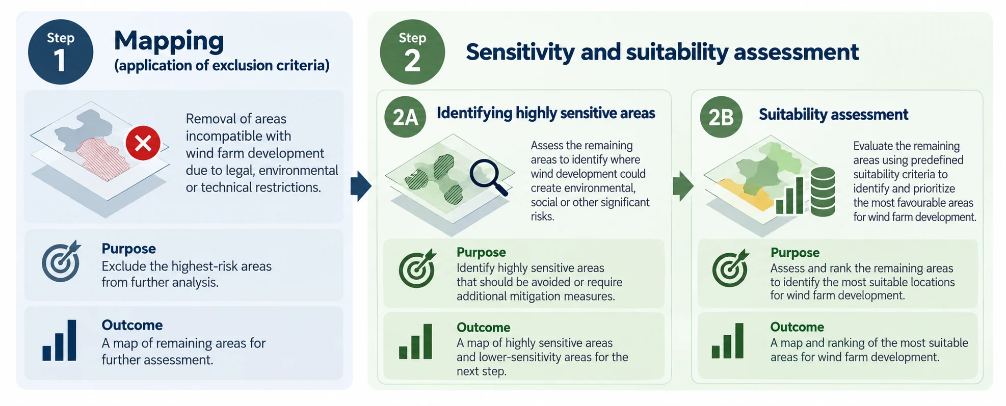
The project to identify the most suitable areas for wind farm development as potential candidate territories, is structured around two main phases: a mapping phase and sensitivity and suitability analysis.
The methodological approach
Methodological description and criteria tables are available in English and Ukrainian. The linked documents have been updated to match this publication.
Methodological workflow from the updated Methodological Approach document (13 October 2026).
1
Картографування
Застосування критеріїв виключення
Визначаються території, непридатні для розміщення вітрових електростанцій через правові, екологічні або технічні обмеження.
Результат: найчутливіші ділянки вилучаються з подальшого аналізу.
➜
2А
Оцінювання чутливості
Визначення високочутливих територій
Перевіряються природні, соціальні та інші ризики для решти території з урахуванням потреби уникнення впливів або пом'якшувальних заходів.
Результат: визначення зон, які слід виключити з подальшого оцінювання.
➜
2Б
Оцінювання придатності
Порівняння територій за критеріями
Оцінюються вітровий ресурс, природа, соціально-економічні фактори, інфраструктура та землекористування.
Результат: пріоритезація ділянок для подальшого вивчення.
Five thematic data groups
Nature values and biodiversity — High ecological value areas, protected areas, priority bird and bat habitats and ecological corridors.
Planning constraints and land use — Terrain, elevation, slope and land cover relevant to wind development.
Socioeconomic — Settlements, population and cultural heritage constraints.
Infrastructure — Transport, transmission infrastructure, airports and existing wind farms.
Wind — Wind speed and other wind conditions influencing suitability and development potential.
Step 1 · Mapping
Application of exclusion criteria
During the mapping phase, exclusion criteria were applied to identify and remove areas where wind farm development could potentially result in significant adverse environmental, social, or other impacts, or where development would be incompatible with existing legal, environmental, or technical restrictions. These areas were excluded from further assessment.
The mapping process was based on the methodology and spatial information developed within the REZOMA project. As part of the preparatory work, the available spatial datasets were reviewed to identify opportunities to incorporate more accurate, up-to-date, or higher-resolution data, thereby improving the reliability and spatial precision of the assessment. In parallel, relevant legislation and regulatory requirements were reviewed to determine whether any additional exclusion criteria or changes to existing restrictions needed to be considered. This process ensured that the mapping approach was based on the best available spatial data, reflected the current regulatory framework, and provided a consistent and reliable basis for the subsequent sensitivity and suitability assessment (Step 2).
Exclusion 1 · Mapping criteria
Stage 1 mapping criteria from the supplied Excel workbook. Buffer distances and listed data sources describe the methodological reference table; actual run settings are controlled by the selected scenario.
Step 2A · Identification of highly sensitive areas
Areas remaining after mapping were assessed using environmental, social, technical and other relevant criteria to identify locations highly sensitive to wind farm development. Such areas were excluded because of potential environmental constraints.
Step 2A · Highly sensitive areas — criteria
Reference criteria from STAGE 2 of the supplied Excel workbook. Exclusion 2 removes candidate projects; it does not erase already assessed score cells.
Data group
Criteria
Exclusion distance
Reference
Data source
Socioeconomic aspects
UNESCO world heritage (points, polygons)
< 25 km
UNESCO
Planning constraints and land use
Border strip
< 5 km
PAEW
Areas with a probability of flooding of 1%
0 m
JRC Data Catalogue
Suitable area for wind farm construction >= 100 MW
<6,5 km2
Real-case
Infrastructure
Meteorological radars (C band)
< 20 km
EUMETNET/WMO recommendation
Distance to transmission lines
> 15 km
OSM
Nature values and biodiversity
Areas with high level density of observations of endangered species
0 m
GBIF
Plant species or plant communities listed in the Red Book or Green Book
50 m
GBIF
Forest
200 m
EUROBAT guidelines
OSM
Key Biodiversity Areas (KBA)
1000 m
Rezoma
Key biodiversity areas
Important underground sites for bats
1000 m
Rezoma
EUROBAT
Wind
Existing wind parks
1000 m
OSM
Occupied territories
Occupied territories
0 km
Step 2B · Suitability assessment
Following the identification of highly sensitive areas, the remaining locations were evaluated on a predefined scale using suitability criteria to compare and prioritize possible wind farm locations. The weighted evaluation groups and their distance or resource bands are provided in the table below.
Evaluation criteria · Weighted suitability
Less suitableMore suitable
Revised Stage 3 scoring, as supplied on 12 October 2026. Values describe the evaluation criteria; actual calculations follow the selected tool scenario. Blank soil bands remain blank in the supplied revision.
Buildings and residential zones are evaluated separately from heritage, but not added to populated places as a second population score: the tool uses the lower of the buildings/residential score and the cities/villages score for the population component (75% of the socioeconomic group). Cultural heritage contributes the other 25%. The building source covers OSM building footprints and prepared residential zones; hospitals and other public buildings are included only where present in those inputs, not as a separate hospital scoring rule.
Data group
Layers
Exclusion criteria
Evaluation parameters
Weight
Socioeconomic
Cities, villages
1500 m
0–1500 m1500–3000 m
20%
Buildings and residential zones (including public buildings where mapped)
Footprint + 700 m exclusion (Step 1)
0–1500 m>1500–3000 m>3000 m
Cultural heritage
100 m within settlements; 300 m outside settlements
300–1500 m1500–3000 m
Infrastructure
Energy infrastructure – transmission lines
375 m
375–5000 m5000–10,000 m10,000–15,000 m
30%
Distance to roads
375 m
<5000 m5000–10,000 m10,000–15,000 m
Substations
375 m
375–2000 m2000–5000 m5000–10,000 m10,000–20,000 m
Nature
Natural reserves, nationally protected areas (WDPA)
Footprints + 1000 m
1000–2000 m
25%
Key Biodiversity Areas (KBA), including IBA
Footprints + 1000 m
1000–5000 m5000–10,000 m
Wind
Wind speed
<3200 FLH
<7 m/s7–8 m/s>8 m/s
20%
Planning constraints and land use
Valuable agricultural land (valuable soils)
5%
Data and limitations
The geospatial datasets used for this assessment were based on publicly available information obtained from major open-access databases and data platforms. These datasets provide a useful basis for preliminary spatial screening and identification of potential environmental constraints.
However, the availability and completeness of data remain limited, and additional data sources should be incorporated in future assessments to improve the accuracy and reliability of the analysis.
The analysis uses a 25 × 25 m spatial assessment cell (625 m²). This resolution supports national screening but limits the precision of local boundaries; it should not be interpreted as a turbine-placement, cadastral or field-survey boundary.
Candidate territories for onshore wind in Ukraine.
The project “Renewables Acceleration Areas in Ukraine – a tool for green rebuilding” contributes to Ukraine’s alignment with EU environmental and climate legislation by identifying potential candidate areas through environmentally responsible spatial planning and renewable-energy screening.
The project is implemented with financial support from the Ministry of Foreign Affairs of the Republic of Latvia.
Original project artwork and partner credits, as supplied. The application and map use the name Candidate territories.
About the project
Estonian, Latvian & Lithuanian Environment (ELLE), together with the Professional Association of Environmentalists of the World (PAEW) in Ukraine, is implementing the project with funding from Latvia’s development cooperation programme administered by the Ministry of Foreign Affairs of the Republic of Latvia.
The objective is to support national identification of potential Renewable Acceleration Areas (RAAs), in alignment with the revised Renewable Energy Directive (RED III), environmental protection requirements and sustainable spatial planning.
The identified territories are candidates only. They have not been legally designated as RAAs under this project and do not automatically qualify for accelerated permitting.
Potential uses
Evidence for future RAA designation without repeating the initial mapping.
Supporting national, regional and local spatial plans.
Informing grid-connection and reinforcement planning.
Preliminary screening by authorities and developers.
Prioritising new biodiversity and local-data studies.
Comparing alternative locations and identifying potential environmental risks.
Documenting exclusions, sensitivity rules and data limitations transparently.
Previous initiatives in Ukraine
Till now several mapping projects have been conducted in Ukraine, each applying different methodologies and criteria to identify more suitable areas for wind farm development:
Start with the study-area total or select an oblast. Published totals come from the model's analytical summary. Selecting an oblast filters the oblast-split candidate polygons when that layer was published; rasters and reference layers stay unchanged.
02 · Compare
Switch on relevant layers
Use the layer search, five thematic data groups and opacity sliders. Additional archives load on demand. Click a candidate polygon or source feature to view its published attributes. Suitability and area filters apply to candidate polygons, not to source layers.
03 · Interpret
Read results in context
Candidate territories are preliminary screening outputs, not development approvals. Consult the methodological description, source data limitations and local conditions before using results for project decisions.